


Google Maps
Google LLC
I use Google Maps as the place I start when I need to turn a vague plan into something practical: find somewhere to eat, work out how to reach it, check what is nearby, or decide whether a journey is realistic before I leave home. It is a free Travel & Local app from Google LLC, and its huge reach is easy to understand because it combines mapping, navigation, place discovery, and local planning in one familiar screen.
My experience has been very good for ordinary trips, but not flawless. The app is at its best when I need a quick answer based on location and time. It is less convincing when I want a carefully curated travel guide, highly specialized outdoor mapping, or complete confidence that every local detail is current. That distinction matters: Maps is a powerful everyday tool, not a replacement for personal judgment or local knowledge.
From a vague plan to a usable route
My usual starting condition is simple. I know where I want to go, but I do not yet know the best way to get there. Sometimes I have an exact address. More often, I have a business name, a landmark, a neighborhood, or only a need such as “somewhere casual for lunch near the station.” I open the app and search in plain language rather than trying to understand the area from a blank map.
Related News

Bridge Race Transformed: Platform Updates Boost Gameplay

Candy Crush Saga Is Forgiving Until Failure Becomes Unclear

How OS Updates Enhance Roblox Adventures
The first useful decision is whether I am looking for a destination or for inspiration. Searching for a named place usually takes me directly to its listing. Searching for a type of place brings up nearby suggestions, and I can inspect them on the map instead of accepting the first result automatically. I find this especially helpful in unfamiliar areas, where distance alone does not tell me whether a restaurant is actually convenient or separated by a river, a highway, or a difficult crossing.
A place listing can answer several practical questions before I commit. I can check the address, opening information, photos, reviews, and the general position on the map. I also look at nearby streets and landmarks because a pin can appear close to my destination while the entrance is on another road. That small check prevents a surprisingly common mistake: arriving at the right building but approaching it from the wrong side.
Related News

Why WhatsApp Messenger Still Makes Everyday Communication Feel Easy

Jurassic World: The Game Is the Better Dino Tycoon for Strategic Players

Threads in Real Life: Who Should Join, Lurk, or Leave

How SHEIN Turned Shopping Into an Endless Content Feed

How to Make Fortnite Feel Smarter on Mobile

Should You Switch to Microsoft Outlook on Mobile?
The app’s local suggestions are useful when I have time to browse. I can move around the map, compare clusters of places, and use categories to narrow the search. I do not treat the ranking as a final recommendation, though. Popularity, distance, and visibility in search do not necessarily match my preferences. I still read recent comments and inspect the surrounding area before choosing.
Once I select a destination, I tap for directions and choose the travel mode that matches the real trip. Driving, walking, cycling, and public transport can produce very different answers, so I avoid assuming that the quickest car route is relevant to a pedestrian. For a short city journey, walking directions are often more valuable than a straight-line distance because they reveal crossings, entrances, and the actual path through the streets.
For a longer journey, I compare the suggested routes instead of accepting the first one. The fastest option is not always the least stressful. A route with a slightly longer estimate may use simpler roads, avoid a complicated interchange, or make the final approach easier. When I am driving, I pay attention to the route shape before starting, because a glance at the map can reveal whether the app is sending me through a dense center or around it.
Gallery
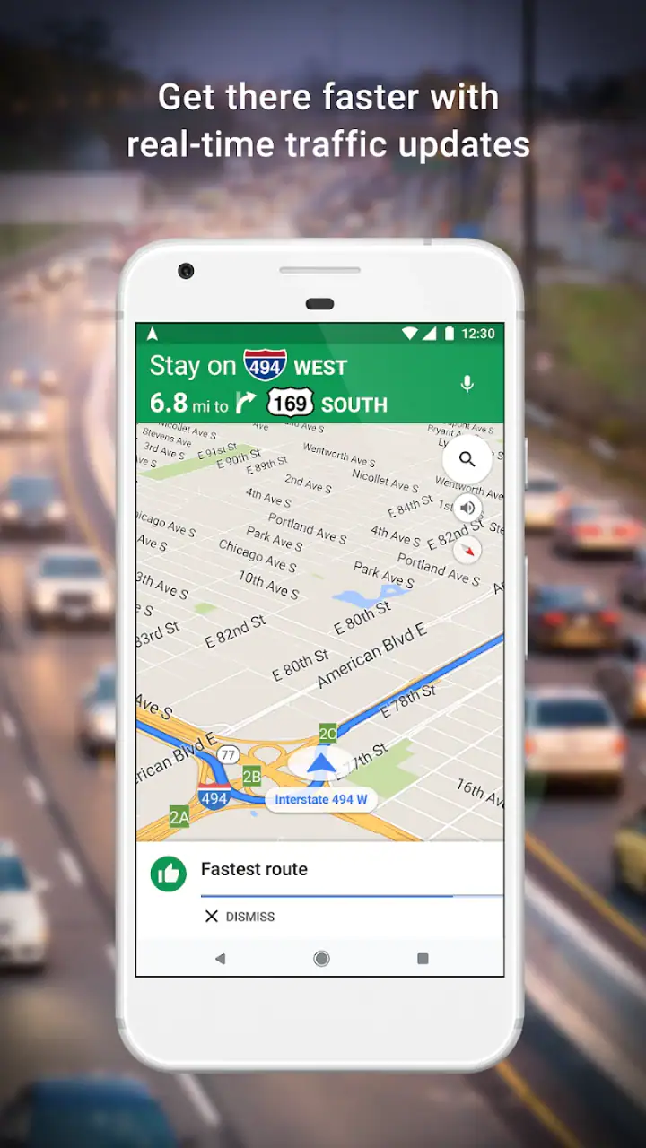
Navigation becomes most useful after the planning stage. Spoken guidance and visual instructions let me keep moving without repeatedly stopping to study the map. I still check the next major turn when I can do so safely, particularly in unfamiliar city centers where several streets look alike. The app reduces the mental work of navigation, but it does not remove the need to watch traffic, signs, and the road itself.
The handoff between discovery and navigation
The strongest part of the workflow is the handoff from finding a place to getting there. I do not need to copy an address into another navigation tool, and I can move from a restaurant listing to directions without rebuilding the search. That continuity is valuable when the destination has a long name, a confusing address, or several branches.
There is another useful handoff between the map and the place listing. I can inspect what is around a destination before starting the journey, then return to the route when I am ready. For example, if I am meeting someone near a busy station, I can search for cafés in the surrounding streets, compare them, and then navigate to the selected one. I find this more practical than using a separate guide for discovery and a separate app for directions.
Sharing also fits naturally into this process. If I am organizing a meeting, I can send the selected place or route to someone else rather than explaining the location from memory. That removes one source of confusion, but it creates a new responsibility: I should share the exact venue, not merely a broad neighborhood pin. A large area can contain several entrances and similarly named businesses.
For group plans, I use the map as a common reference rather than assuming it settles every decision. One person may care about walking time, another about public transport, and another about parking or accessibility. Looking at the route together helps expose those differences early. The app is good at showing the geographic problem; the people involved still need to agree on the practical compromise.
Saved places can make repeated routines faster. I use them for destinations I expect to revisit, such as a particular shop, venue, or meeting point. The benefit is not just speed. Saving the exact listing helps avoid accidentally selecting a similarly named place later. I recommend checking saved locations occasionally, because plans change and an old choice can remain visible long after it stops being useful.
A realistic everyday trip
Imagine I finish work in an unfamiliar part of town and want dinner before taking a train home. My first search is not simply “restaurants.” I look around the station and compare places that appear walkable. I open a few listings, check their position relative to the station entrance, read recent comments for clues about the experience, and look at the surrounding streets.
After choosing one, I request walking directions from my current position. The route may expose a detail I would miss from a restaurant list: the place is technically close, but the entrance is on the opposite side of the block. I can then decide whether the restaurant is still convenient or whether another option makes more sense. If the first choice is busy or closed, returning to the search results is quicker than starting over in a different app.
On the way back, I search for the station and switch the route to the correct entrance or nearby point. This is where I notice both the strength and the limitation of the workflow. Maps connects the pieces smoothly, but the final few minutes can still depend on signs, station layout, and local conditions that are difficult to represent perfectly on a screen.
For a visitor planning a day, the same process works at a larger scale. I can mark several possible stops, inspect the distance between them, and build a sensible order rather than choosing attractions one at a time. I would not let the app design the entire trip for me, but it is excellent for testing whether an ambitious list fits into the available day.
Where local information helps and where it needs checking
Local discovery is one of the reasons I return to Maps instead of using only a dedicated route planner. The app can connect a place to nearby food, events, activities, and other useful destinations. That makes it valuable when I am already in an area and want to make a decision without knowing the local vocabulary.
However, local information needs a quick reality check. Opening hours can change, businesses can move, and a listing may not communicate a temporary entrance change or an event-specific restriction. I treat the listing as a strong starting point, not a guarantee. For an important appointment, I confirm the time directly with the venue or allow enough flexibility to handle an outdated detail.
Reviews are most helpful when I read them for patterns rather than for a single dramatic opinion. I look for repeated comments about location, service, noise, queues, or suitability for the reason I am visiting. A high average alone does not tell me whether a place is right for my situation. Conversely, a lower average may reflect an issue that does not matter to me, while a small recurring complaint might matter a great deal.
Photos can also be more useful than they first appear. I use them to identify entrances, understand the layout, and judge whether a place looks suitable for a particular plan. They are not a substitute for current information, but they can prevent an awkward arrival, especially when a venue is inside a shopping center, a station, or a large complex.
How it compares with other choices
Compared with a basic navigation app, Maps gives me a broader path from “I need something” to “I am on my way.” A route-only tool may feel cleaner when I already know the exact destination and want minimal distraction. Maps earns its place when the destination itself is part of the question.
Compared with a dedicated public transport app, it is more convenient for mixed journeys that combine walking with a train or bus. A local transit app may provide more specialized detail for one network, particularly when I need service notices, fare information, or a deep understanding of local routes. For a visitor who does not know the network, Maps is often easier to approach, but I would still check the operator’s information for a critical trip.
Compared with specialist outdoor mapping, it is not my first choice for demanding hikes, remote terrain, or situations where trail detail and offline reliability are central. Maps is designed for broad everyday usefulness. A specialist tool can be better when the consequences of a wrong turn are higher or when a route leaves ordinary streets.
Compared with a curated travel guide, Maps offers more flexibility and immediate location awareness, while a guide may provide stronger editorial context. I use Maps to answer “what is near me and how do I get there?” I use a guide when I want to understand the character of a destination or choose between experiences based on a trusted point of view.
Practical friction I notice during use
The interface can feel busy because it tries to serve drivers, pedestrians, commuters, tourists, and local shoppers at once. Search results, map labels, place information, and route controls compete for attention. I have learned to pause before starting navigation and confirm the destination, travel mode, and route rather than tapping through automatically.
Search interpretation is another source of friction. A familiar business name can produce several branches, and a broad search can mix places that are technically nearby but inconvenient for my actual journey. I always check the map position and address. This extra step is small, but skipping it is the fastest way to navigate to the wrong branch.
Traffic and travel estimates are useful for planning, yet I do not treat them as promises. Congestion can change, a road can be blocked, and a public transport connection can be missed. I build a buffer into important journeys. The app improves my estimate; it does not control the conditions that determine whether I arrive on time.
Privacy is also part of my decision. A location-based service becomes more useful when it knows where I am, but I am careful about which location and activity settings I enable. People who strongly prefer minimal location sharing may find the convenience less attractive. In that case, a simpler map or manually entered route may be a better compromise, even if it requires more effort.
Another trade-off is dependence on a phone during the trip. A navigation screen is helpful, but it can drain attention and make a journey feel more complicated than necessary. I prefer to review the route before leaving, note the major turns, and use the app as support rather than stare at it continuously. For driving, safe use matters more than following every small change on screen.
Who will get the most from it?
I recommend Maps most strongly to people who move between familiar routines and unfamiliar places. It suits commuters checking a new route, visitors exploring a city, drivers comparing options, and anyone who often needs to find a business or service nearby. It is also useful for people coordinating with others because a precise listing is easier to share than a verbal description.
It is particularly good for the “last mile” of a plan. I may know the train station, shopping center, or neighborhood, but not the exact entrance or street. The app helps connect that broad destination to a practical walking route. This is a less glamorous use than turn-by-turn driving, but it is one of the reasons I find it dependable in daily life.
I would suggest a different primary tool for someone who needs deep trail navigation, highly detailed transit operations, or a distraction-free route display. I would also be cautious about recommending it as the only source for a time-sensitive appointment, a remote journey, or a place where an outdated listing could cause serious trouble.
The app is free and rated for Everyone, which makes it approachable for a wide range of users. Its scale is reflected in more than ten billion installs, while its average rating sits at about 3.2 from roughly nineteen million ratings. I read that combination as a useful reminder: enormous reach does not mean every user has the same experience, and a low average should encourage realistic expectations rather than automatic dismissal.
For me, the value comes from the complete chain: search, inspect, compare, choose, share, and navigate. Each step is familiar, and the handoff between them saves time. The result is usually a clearer decision and a more manageable journey, especially when I begin with incomplete information.
My final view after using the whole workflow
Google Maps is the app I would keep ready for ordinary movement and local decisions. It does more than draw roads: it helps me turn a need into a destination, a destination into a route, and a route into an arrival plan. That makes it more useful than a simple map and more flexible than a single-purpose navigation tool.
Its weaknesses are real. Listings can require verification, route estimates can change, the interface can feel crowded, and specialist alternatives may be better for transit networks or remote trails. I also think users should avoid treating rankings, reviews, or automated directions as unquestionable truth.
Still, when I need one free app for finding places, checking what is around them, comparing ways to travel, and reaching the final entrance, it remains my practical recommendation. The best way to use it is as an informed assistant: let it reduce the searching and route-planning work, then apply your own judgment to the details that matter.
FAQs for Google Maps
What features does Google Maps offer for navigation?
Google Maps provides a comprehensive suite of navigation features, including real-time GPS navigation, traffic conditions, and public transport information. Users can also access offline maps, explore local areas with Street View, and receive step-by-step directions. The app supports multiple modes of transport, such as driving, walking, biking, and public transit.
How does Google Maps ensure the accuracy of its maps and data?
Google Maps uses a combination of satellite imagery, user-submitted data, and real-time feedback to maintain accurate and up-to-date maps. The app regularly updates its information through data partnerships and contributions from millions of users worldwide, who can report errors or suggest changes directly within the app.
Can I use Google Maps offline, and how do I download offline maps?
Yes, Google Maps allows users to download offline maps for use without an internet connection. To download, search for the desired location, tap on the location name or address, and select the 'Download' option. Offline maps are particularly useful in areas with limited connectivity and can be accessed anytime.
What privacy settings are available in Google Maps?
Google Maps offers several privacy controls, including Incognito Mode, which prevents searches and locations from being saved to your Google account. Users can also manage location history and activity data, as well as customize ad personalization settings. The app provides clear access to privacy settings for enhanced user control.
Is Google Maps free to use, and are there any in-app purchases?
Google Maps is a free application available to all users with a Google account. There are no in-app purchases required to access its basic features. However, some third-party services integrated with Google Maps, like ride-sharing or parking reservations, may involve separate charges outside of the app.
Pros
- Highly accurate real-time navigation.
- Extensive database of locations worldwide.
- Street View offers immersive visuals.
- Offline maps for data savings.
- Frequent updates with new features.
Cons
- Battery drain during prolonged use.
- Occasional GPS signal loss.
- Data-heavy without offline maps.
- Privacy concerns with location tracking.
- Can be complex for new users.


